Make a donation
Gear up for your next adventure:
As an Amazon Associate, this site earns from qualifying purchases at no extra cost to you.
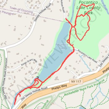
Pocantico Lake County Park - White Trail and Dam
- Distance: 3.5 mi
- Elevation gain: 331 ft
- Maximum elevation: 361 ft
- Elevation loss: 331 ft
- Minimum elevation: 187 ft
- Moving time: 1 h 7 m
- Moving speed: 3.2 mph
- Maximum speed: 5.7 mph
- Total time: 1 h 12 m
- Global speed: 2.9 mph
Interactive trail map
Make a donation
Gear up for your next adventure:
As an Amazon Associate, this site earns from qualifying purchases at no extra cost to you.
Trail profile
- Distance: 3.5 mi
- Elevation gain: 331 ft
- Maximum elevation: 361 ft
- Elevation loss: 331 ft
- Minimum elevation: 187 ft
- Moving time: 1 h 7 m
- Moving speed: 3.2 mph
- Maximum speed: 5.7 mph
- Total time: 1 h 12 m
- Global speed: 2.9 mph
Make a donation
Gear up for your next adventure:
As an Amazon Associate, this site earns from qualifying purchases at no extra cost to you.
About this trail
Name: Pocantico Lake County Park - White Trail and Dam trail, distance, elevation, map, profile, GPS track
Coordinates: 41.11156 -73.84185 41.12261 -73.83023
Topography: Westchester County topographic map, elevation, terrain
Make a donation
Gear up for your next adventure:
As an Amazon Associate, this site earns from qualifying purchases at no extra cost to you.
Other hiking, mountain biking, running and outdoor activity trails
Click on a trail to view its statistics, map and profile.
Rockefeller State Park Preserve
United States > New York > Westchester County > Town of Mount Pleasant
Distance: 4.2 mi • Elevation gain: 384 ft • Maximum elevation: 410 ft
Rockefeller State Park loop hike
United States > New York > Westchester County > Village of Sleepy Hollow
Distance: 6.8 mi • Elevation gain: 604 ft • Maximum elevation: 515 ft
Rockefeller State Park trails
United States > New York > Westchester County > Town of Mount Pleasant
Distance: 6.3 mi • Elevation gain: 722 ft • Maximum elevation: 443 ft
Make a donation
Gear up for your next adventure:
As an Amazon Associate, this site earns from qualifying purchases at no extra cost to you.