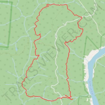
Mullens Cove Loop Trail - Prentice Cooper State Forest
- Distance: 10.4 mi
- Elevation gain: 2,251 ft
- Maximum elevation: 1,870 ft
- Elevation loss: 2,254 ft
- Minimum elevation: 1,348 ft
- Moving time: 5 h 22 m
- Moving speed: 1.9 mph
- Maximum speed: 4.3 mph
- Total time: 6 h 29 m
- Global speed: 1.6 mph
Interactive trail map
Trail profile
- Distance: 10.4 mi
- Elevation gain: 2,251 ft
- Maximum elevation: 1,870 ft
- Elevation loss: 2,254 ft
- Minimum elevation: 1,348 ft
- Moving time: 5 h 22 m
- Moving speed: 1.9 mph
- Maximum speed: 4.3 mph
- Total time: 6 h 29 m
- Global speed: 1.6 mph
About this trail
Name: Mullens Cove Loop Trail - Prentice Cooper State Forest trail, distance, elevation, map, profile, GPS track
Coordinates: 35.10021 -85.44759 35.13789 -85.41857
Topography: Marion County topographic map, elevation, terrain
Other hiking, mountain biking, running and outdoor activity trails
Click on a trail to view its statistics, map and profile.
Pot Point Loop Hike in Prentice Cooper State Forest
United States > Tennessee > Marion County
Distance: 11.6 mi • Elevation gain: 2,123 ft • Maximum elevation: 1,854 ft