Make a donation
Gear up for your next adventure:
As an Amazon Associate, this site earns from qualifying purchases at no extra cost to you.
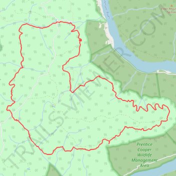
Pot Point Loop Hike in Prentice Cooper State Forest
- Distance: 11.6 mi
- Elevation gain: 2,123 ft
- Maximum elevation: 1,854 ft
- Elevation loss: 2,123 ft
- Minimum elevation: 1,444 ft
- Moving time: 4 h 3 m
- Moving speed: 2.9 mph
- Maximum speed: 5.9 mph
- Total time: 4 h 33 m
- Global speed: 2.5 mph
Interactive trail map
Make a donation
Gear up for your next adventure:
As an Amazon Associate, this site earns from qualifying purchases at no extra cost to you.
Trail profile
- Distance: 11.6 mi
- Elevation gain: 2,123 ft
- Maximum elevation: 1,854 ft
- Elevation loss: 2,123 ft
- Minimum elevation: 1,444 ft
- Moving time: 4 h 3 m
- Moving speed: 2.9 mph
- Maximum speed: 5.9 mph
- Total time: 4 h 33 m
- Global speed: 2.5 mph
Make a donation
Gear up for your next adventure:
As an Amazon Associate, this site earns from qualifying purchases at no extra cost to you.
About this trail
Name: Pot Point Loop Hike in Prentice Cooper State Forest trail, distance, elevation, map, profile, GPS track
Coordinates: 35.07009 -85.44377 35.10177 -85.39633
Topography: Marion County topographic map, elevation, terrain
Make a donation
Gear up for your next adventure:
As an Amazon Associate, this site earns from qualifying purchases at no extra cost to you.
Other hiking, mountain biking, running and outdoor activity trails
Click on a trail to view its statistics, map and profile.
Mullens Cove Loop Trail - Prentice Cooper State Forest
United States > Tennessee > Marion County
Distance: 10.4 mi • Elevation gain: 2,251 ft • Maximum elevation: 1,870 ft