Birdlip Loop via Witcombe Reservoirs
- Distance: 4.9 mi
- Elevation gain: 837 ft
- Maximum elevation: 958 ft
- Elevation loss: 751 ft
- Minimum elevation: 282 ft
- Moving time: 2 h 1 m
- Moving speed: 2.4 mph
- Maximum speed: 8.9 mph
- Total time: 2 h 32 m
- Global speed: 1.9 mph
Interactive trail map
Trail profile
- Distance: 4.9 mi
- Elevation gain: 837 ft
- Maximum elevation: 958 ft
- Elevation loss: 751 ft
- Minimum elevation: 282 ft
- Moving time: 2 h 1 m
- Moving speed: 2.4 mph
- Maximum speed: 8.9 mph
- Total time: 2 h 32 m
- Global speed: 1.9 mph
About this trail
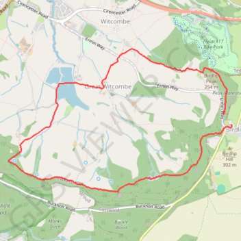
Name: Birdlip Loop via Witcombe Reservoirs trail, distance, elevation, map, profile, GPS track
Coordinates: 51.82080 -2.14982 51.83675 -2.10960
Other hiking, mountain biking, running and outdoor activity trails
Click on a trail to view its statistics, map and profile.
Painswick Witcombe
United Kingdom > England > Gloucestershire > Painswick > Ham Butts
Distance: 11.6 mi • Elevation gain: 1,736 ft • Maximum elevation: 915 ft
Dean2023-311
United Kingdom > England > Oxfordshire > Oxford
Distance: 192.8 mi • Elevation gain: 11,043 ft • Maximum elevation: 951 ft