Catawba Falls River Trail in Pisgah National Forest
The Catawba Falls Trail offers a scenic journey through Pisgah National Forest, guiding hikers along a gentle riverside path rich with historic stonework, lush vegetation, and streams that punctuate the quiet, wooded landscape. About halfway up, hikers encounter a historic dam that forms a small waterfall, while the lower and upper Catawba Falls provide the main attractions, with tiered cascades and a pool at the base of the lower falls. Stairways and a bridge enhance accessibility and safety on this popular trail, making it an ideal adventure for both novice and seasoned hikers seeking a tranquil yet visually rewarding hike in the Blue Ridge Mountains. #Hiking #Waterfall #River #Forest #Nature
- Distance: 2.5 mi
- Elevation gain: 673 ft
- Maximum elevation: 2,280 ft
- Elevation loss: 676 ft
- Minimum elevation: 1,604 ft
- Moving time: 56 m 19 s
- Moving speed: 2.7 mph
- Maximum speed: 4.5 mph
- Total time: 1 h 2 m
- Global speed: 2.4 mph
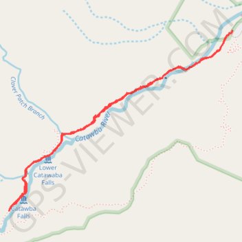
Interactive trail map
Trail profile
- Distance: 2.5 mi
- Elevation gain: 673 ft
- Maximum elevation: 2,280 ft
- Elevation loss: 676 ft
- Minimum elevation: 1,604 ft
- Moving time: 56 m 19 s
- Moving speed: 2.7 mph
- Maximum speed: 4.5 mph
- Total time: 1 h 2 m
- Global speed: 2.4 mph
About this trail
Name: Catawba Falls River Trail in Pisgah National Forest trail, distance, elevation, map, profile, GPS track
Coordinates: 35.60334 -82.24623 35.61345 -82.23085
Topography: McDowell County topographic map, elevation, terrain
Other hiking, mountain biking, running and outdoor activity trails
Click on a trail to view its statistics, map and profile.
Catawba Falls Trail
United States > North Carolina > McDowell County
Distance: 2.4 mi • Elevation gain: 587 ft • Maximum elevation: 2,096 ft