Thank you for supporting this site ❤️
Make a donation
Make a donation
Gear up for your next adventure:
As an Amazon Associate, this site earns from qualifying purchases at no extra cost to you.
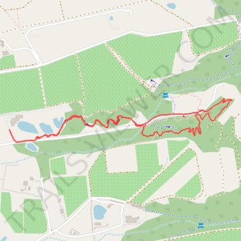
Element Mont Marie
- Distance: 1.9 mi
- Elevation gain: 325 ft
- Maximum elevation: 860 ft
- Elevation loss: 338 ft
- Minimum elevation: 528 ft
- Moving time: 21 m 25 s
- Moving speed: 5.2 mph
- Maximum speed: 16.2 mph
- Total time: 32 m 4 s
- Global speed: 3.5 mph
Interactive trail map
Thank you for supporting this site ❤️
Make a donation
Make a donation
Gear up for your next adventure:
As an Amazon Associate, this site earns from qualifying purchases at no extra cost to you.
Trail profile
- Distance: 1.9 mi
- Elevation gain: 325 ft
- Maximum elevation: 860 ft
- Elevation loss: 338 ft
- Minimum elevation: 528 ft
- Moving time: 21 m 25 s
- Moving speed: 5.2 mph
- Maximum speed: 16.2 mph
- Total time: 32 m 4 s
- Global speed: 3.5 mph
Thank you for supporting this site ❤️
Make a donation
Make a donation
Gear up for your next adventure:
As an Amazon Associate, this site earns from qualifying purchases at no extra cost to you.
About this trail
Name: Element Mont Marie trail, distance, elevation, map, profile, GPS track
Coordinates: -33.98313 18.87159 -33.98130 18.88298
Thank you for supporting this site ❤️
Make a donation
Make a donation
Gear up for your next adventure:
As an Amazon Associate, this site earns from qualifying purchases at no extra cost to you.
Other hiking, mountain biking, running and outdoor activity trails
Click on a trail to view its statistics, map and profile.
Stellenbosch Ride
South Africa > Western Cape > Cape Winelands District Municipality > Stellenbosch Local Municipality > Stellenbosch
Distance: 31.6 mi • Elevation gain: 4,455 ft • Maximum elevation: 1,152 ft