Make a donation
Gear up for your next adventure:
As an Amazon Associate, this site earns from qualifying purchases at no extra cost to you.
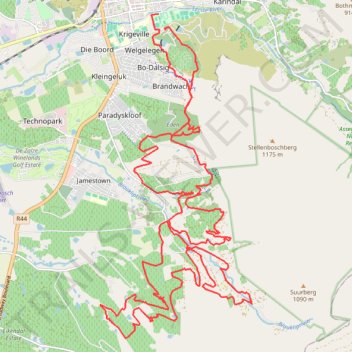
Stellenbosch Ride
- Distance: 31.6 mi
- Elevation gain: 4,455 ft
- Maximum elevation: 1,152 ft
- Elevation loss: 4,413 ft
- Minimum elevation: 374 ft
- Moving time: 3 h 20 m
- Moving speed: 9.4 mph
- Maximum speed: 24.1 mph
- Total time: 3 h 20 m
- Global speed: 9.4 mph
Interactive trail map
Make a donation
Gear up for your next adventure:
As an Amazon Associate, this site earns from qualifying purchases at no extra cost to you.
Trail profile
- Distance: 31.6 mi
- Elevation gain: 4,455 ft
- Maximum elevation: 1,152 ft
- Elevation loss: 4,413 ft
- Minimum elevation: 374 ft
- Moving time: 3 h 20 m
- Moving speed: 9.4 mph
- Maximum speed: 24.1 mph
- Total time: 3 h 20 m
- Global speed: 9.4 mph
Make a donation
Gear up for your next adventure:
As an Amazon Associate, this site earns from qualifying purchases at no extra cost to you.
About this trail
Name: Stellenbosch Ride trail, distance, elevation, map, profile, GPS track
Coordinates: -34.01722 18.85111 -33.93924 18.89488
Make a donation
Gear up for your next adventure:
As an Amazon Associate, this site earns from qualifying purchases at no extra cost to you.
Other hiking, mountain biking, running and outdoor activity trails
Click on a trail to view its statistics, map and profile.
Element Mont Marie
South Africa > Western Cape > Cape Winelands District Municipality > Stellenbosch Local Municipality
Distance: 1.9 mi • Elevation gain: 325 ft • Maximum elevation: 860 ft
Eden
South Africa > Western Cape > Cape Winelands District Municipality > Stellenbosch Local Municipality > Stellenbosch
Distance: 2.0 mi • Elevation gain: 367 ft • Maximum elevation: 988 ft