Make a donation
Gear up for your next adventure:
As an Amazon Associate, this site earns from qualifying purchases at no extra cost to you.
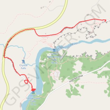
Upper Yellowstone Falls - North Rim Trail
Yellowstone National Park
- Distance: 1.9 mi
- Elevation gain: 423 ft
- Maximum elevation: 7,828 ft
- Elevation loss: 328 ft
- Minimum elevation: 7,562 ft
- Moving time: 14 m 27 s
- Moving speed: 7.7 mph
- Maximum speed: 33.4 mph
- Total time: 17 m 36 s
- Global speed: 6.4 mph
Interactive trail map
Make a donation
Gear up for your next adventure:
As an Amazon Associate, this site earns from qualifying purchases at no extra cost to you.
Trail profile
- Distance: 1.9 mi
- Elevation gain: 423 ft
- Maximum elevation: 7,828 ft
- Elevation loss: 328 ft
- Minimum elevation: 7,562 ft
- Moving time: 14 m 27 s
- Moving speed: 7.7 mph
- Maximum speed: 33.4 mph
- Total time: 17 m 36 s
- Global speed: 6.4 mph
Make a donation
Gear up for your next adventure:
As an Amazon Associate, this site earns from qualifying purchases at no extra cost to you.
About this trail
Name: Upper Yellowstone Falls - North Rim Trail trail, distance, elevation, map, profile, GPS track
Start: North Rim Trail, Park County, Wyoming, United States (44.71350 -110.50009)
End: North Rim Drive, Park County, Wyoming, United States (44.72156 -110.48735)
Coordinates: 44.71299 -110.50481 44.72173 -110.48734
Topography: Park County topographic map, elevation, terrain
Make a donation
Gear up for your next adventure:
As an Amazon Associate, this site earns from qualifying purchases at no extra cost to you.
Other hiking, mountain biking, running and outdoor activity trails
Click on a trail to view its statistics, map and profile.
Canyon Lookout Point - Red Rock Point - Yellowstone River
United States > Wyoming > Park County
Yellowstone National Park
Distance: 1.0 mi • Elevation gain: 394 ft • Maximum elevation: 7,740 ft