Thank you for supporting this site ❤️
Make a donation
Make a donation
Gear up for your next adventure:
As an Amazon Associate, this site earns from qualifying purchases at no extra cost to you.
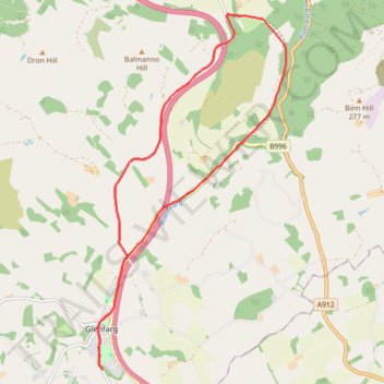
Glenfarg Railway Tunnels Circular
- Distance: 8.1 mi
- Elevation gain: 669 ft
- Maximum elevation: 650 ft
- Elevation loss: 666 ft
- Minimum elevation: 197 ft
- Moving time: 55 m 20 s
- Moving speed: 8.8 mph
- Maximum speed: 22.8 mph
- Total time: 1 h 2 m
- Global speed: 7.9 mph
Interactive trail map
Thank you for supporting this site ❤️
Make a donation
Make a donation
Gear up for your next adventure:
As an Amazon Associate, this site earns from qualifying purchases at no extra cost to you.
Trail profile
- Distance: 8.1 mi
- Elevation gain: 669 ft
- Maximum elevation: 650 ft
- Elevation loss: 666 ft
- Minimum elevation: 197 ft
- Moving time: 55 m 20 s
- Moving speed: 8.8 mph
- Maximum speed: 22.8 mph
- Total time: 1 h 2 m
- Global speed: 7.9 mph
Thank you for supporting this site ❤️
Make a donation
Make a donation
Gear up for your next adventure:
As an Amazon Associate, this site earns from qualifying purchases at no extra cost to you.
About this trail
Name: Glenfarg Railway Tunnels Circular trail, distance, elevation, map, profile, GPS track
Coordinates: 56.27321 -3.40144 56.31958 -3.35714
Thank you for supporting this site ❤️
Make a donation
Make a donation
Gear up for your next adventure:
As an Amazon Associate, this site earns from qualifying purchases at no extra cost to you.
Other hiking, mountain biking, running and outdoor activity trails
Click on a trail to view its statistics, map and profile.
Glenfarg North Tunnel
United Kingdom > Scotland > Perth and Kinross > Perth > Bein Inn
Distance: 1.3 mi • Elevation gain: 79 ft • Maximum elevation: 335 ft