Make a donation
Gear up for your next adventure:
As an Amazon Associate, this site earns from qualifying purchases at no extra cost to you.
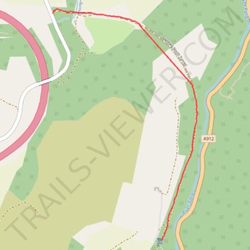
Glenfarg North Tunnel
- Distance: 1.3 mi
- Elevation gain: 79 ft
- Maximum elevation: 335 ft
- Elevation loss: 177 ft
- Minimum elevation: 197 ft
Interactive trail map
Make a donation
Gear up for your next adventure:
As an Amazon Associate, this site earns from qualifying purchases at no extra cost to you.
Trail profile
- Distance: 1.3 mi
- Elevation gain: 79 ft
- Maximum elevation: 335 ft
- Elevation loss: 177 ft
- Minimum elevation: 197 ft
Make a donation
Gear up for your next adventure:
As an Amazon Associate, this site earns from qualifying purchases at no extra cost to you.
About this trail
Name: Glenfarg North Tunnel trail, distance, elevation, map, profile, GPS track
End: Aberargie, Perth and Kinross, Scotland, PH2 9HH, United Kingdom (56.31940 -3.37099)
Coordinates: 56.30717 -3.37099 56.31962 -3.35701
Make a donation
Gear up for your next adventure:
As an Amazon Associate, this site earns from qualifying purchases at no extra cost to you.
Other hiking, mountain biking, running and outdoor activity trails
Click on a trail to view its statistics, map and profile.
Glenfarg Railway Tunnels Circular
United Kingdom > Scotland > Perth and Kinross > Glenfarg > Arngask
Distance: 8.1 mi • Elevation gain: 669 ft • Maximum elevation: 650 ft