Thank you for supporting this site ❤️
Make a donation
Make a donation
Gear up for your next adventure:
As an Amazon Associate, this site earns from qualifying purchases at no extra cost to you.
Queen Elizabeth II Wildlands Provincial Park
Interactive trail map
Thank you for supporting this site ❤️
Make a donation
Make a donation
Gear up for your next adventure:
As an Amazon Associate, this site earns from qualifying purchases at no extra cost to you.
Trail profile
- Distance: 7.8 mi
- Elevation gain: 312 ft
- Maximum elevation: 863 ft
- Elevation loss: 308 ft
- Minimum elevation: 794 ft
Thank you for supporting this site ❤️
Make a donation
Make a donation
Gear up for your next adventure:
As an Amazon Associate, this site earns from qualifying purchases at no extra cost to you.
About this trail
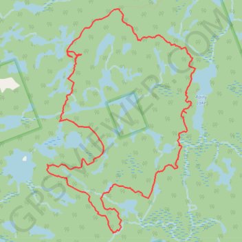
Name: Queen Elizabeth II Wildlands Provincial Park trail, distance, elevation, map, profile, GPS track
Start: Kawartha Lakes, Central Ontario, Ontario, Canada (44.77878 -79.11452)
End: Kawartha Lakes, Central Ontario, Ontario, Canada (44.77875 -79.11451)
Coordinates: 44.75058 -79.12732 44.77878 -79.10103
Thank you for supporting this site ❤️
Make a donation
Make a donation
Gear up for your next adventure:
As an Amazon Associate, this site earns from qualifying purchases at no extra cost to you.
Other hiking, mountain biking, running and outdoor activity trails
Click on a trail to view its statistics, map and profile.