Georgian Bay Islands National Park
Lake Huron. Beausoleil Island. #Hiking #Loop #Georgian #Beausoleil #Huron
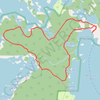
- Distance: 4.9 mi
- Elevation gain: 200 ft
- Maximum elevation: 640 ft
- Elevation loss: 203 ft
- Minimum elevation: 584 ft
Interactive trail map
Trail profile
- Distance: 4.9 mi
- Elevation gain: 200 ft
- Maximum elevation: 640 ft
- Elevation loss: 203 ft
- Minimum elevation: 584 ft
About this trail
Name: Georgian Bay Islands National Park trail, distance, elevation, map, profile, GPS track
Coordinates: 44.87917 -79.87837 44.89339 -79.84839
Other hiking, mountain biking, running and outdoor activity trails
Click on a trail to view its statistics, map and profile.