Charles H. Bronson State Forest
Hike in Charles H. Bronson State Forest from Joshua Creek Trailhead via Florida Trail and River Trail. #Hiking #Nature #Forest
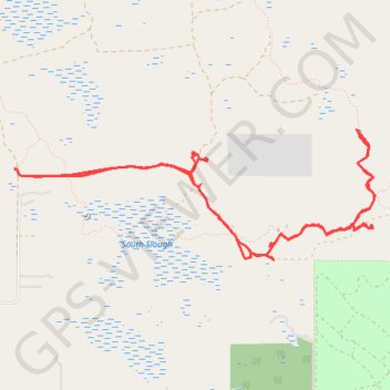
- Distance: 8.1 mi
- Elevation gain: 69 ft
- Maximum elevation: 49 ft
- Elevation loss: 72 ft
- Minimum elevation: 13 ft
- Moving time: 4 h 48 m
- Moving speed: 1.7 mph
- Maximum speed: 2.7 mph
- Total time: 6 h 49 m
- Global speed: 1.2 mph
Interactive trail map
Trail profile
- Distance: 8.1 mi
- Elevation gain: 69 ft
- Maximum elevation: 49 ft
- Elevation loss: 72 ft
- Minimum elevation: 13 ft
- Moving time: 4 h 48 m
- Moving speed: 1.7 mph
- Maximum speed: 2.7 mph
- Total time: 6 h 49 m
- Global speed: 1.2 mph
About this trail
Name: Charles H. Bronson State Forest trail, distance, elevation, map, profile, GPS track
Start: Joshua Creek TH Spur, Orange County, Florida, 32709, United States (28.59139 -81.04058)
End: Joshua Creek TH Spur, Orange County, Florida, 32709, United States (28.59184 -81.04245)
Coordinates: 28.58403 -81.04254 28.59539 -81.00692
Topography: Orange County topographic map, elevation, terrain