Make a donation
Gear up for your next adventure:
As an Amazon Associate, this site earns from qualifying purchases at no extra cost to you.
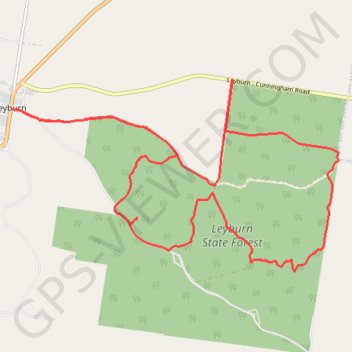
Leyburn State Forest
Interactive trail map
Make a donation
Gear up for your next adventure:
As an Amazon Associate, this site earns from qualifying purchases at no extra cost to you.
Trail profile
- Distance: 17.0 mi
- Elevation gain: 1,621 ft
- Maximum elevation: 1,867 ft
- Elevation loss: 1,621 ft
- Minimum elevation: 1,362 ft
Make a donation
Gear up for your next adventure:
As an Amazon Associate, this site earns from qualifying purchases at no extra cost to you.
About this trail
Name: Leyburn State Forest trail, distance, elevation, map, profile, GPS track
Start: Leyburn Forestry Road, Leyburn, Southern Downs Regional, Queensland, Australia (-28.01021 151.58650)
End: Leyburn Forestry Road, Leyburn, Southern Downs Regional, Queensland, Australia (-28.01020 151.58647)
Coordinates: -28.04192 151.58647 -28.00460 151.65822
Make a donation
Gear up for your next adventure:
As an Amazon Associate, this site earns from qualifying purchases at no extra cost to you.
Other hiking, mountain biking, running and outdoor activity trails
Click on a trail to view its statistics, map and profile.