Thank you for supporting this site ❤️
Make a donation
Make a donation
Gear up for your next adventure:
As an Amazon Associate, this site earns from qualifying purchases at no extra cost to you.
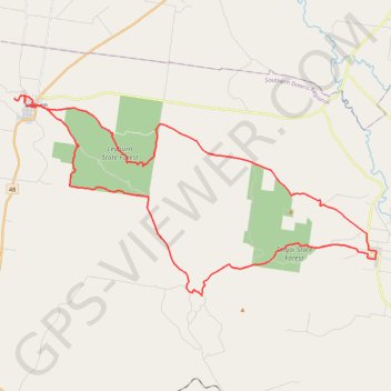
Pratten - Leyburn
Interactive trail map
Thank you for supporting this site ❤️
Make a donation
Make a donation
Gear up for your next adventure:
As an Amazon Associate, this site earns from qualifying purchases at no extra cost to you.
Trail profile
- Distance: 40.1 mi
- Elevation gain: 2,726 ft
- Maximum elevation: 1,854 ft
- Elevation loss: 2,726 ft
- Minimum elevation: 1,348 ft
Thank you for supporting this site ❤️
Make a donation
Make a donation
Gear up for your next adventure:
As an Amazon Associate, this site earns from qualifying purchases at no extra cost to you.
About this trail
Name: Pratten - Leyburn trail, distance, elevation, map, profile, GPS track
Start: White Street, Pratten, Southern Downs Regional, Queensland, Australia (-28.08887 151.78453)
End: White Street, Pratten, Southern Downs Regional, Queensland, Australia (-28.08819 151.78484)
Coordinates: -28.10864 151.57336 -28.00529 151.78488
Thank you for supporting this site ❤️
Make a donation
Make a donation
Gear up for your next adventure:
As an Amazon Associate, this site earns from qualifying purchases at no extra cost to you.
Other hiking, mountain biking, running and outdoor activity trails
Click on a trail to view its statistics, map and profile.