Thank you for supporting this site ❤️
Make a donation
Make a donation
Gear up for your next adventure:
As an Amazon Associate, this site earns from qualifying purchases at no extra cost to you.
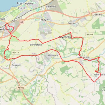
Fa'side Castle loop from Wallyford
- Distance: 21.3 mi
- Elevation gain: 1,165 ft
- Maximum elevation: 446 ft
- Elevation loss: 1,165 ft
- Minimum elevation: 92 ft
Interactive trail map
Thank you for supporting this site ❤️
Make a donation
Make a donation
Gear up for your next adventure:
As an Amazon Associate, this site earns from qualifying purchases at no extra cost to you.
Trail profile
- Distance: 21.3 mi
- Elevation gain: 1,165 ft
- Maximum elevation: 446 ft
- Elevation loss: 1,165 ft
- Minimum elevation: 92 ft
Thank you for supporting this site ❤️
Make a donation
Make a donation
Gear up for your next adventure:
As an Amazon Associate, this site earns from qualifying purchases at no extra cost to you.
About this trail
Name: Fa'side Castle loop from Wallyford trail, distance, elevation, map, profile, GPS track
Coordinates: 55.88917 -3.01774 55.94156 -2.86330
Thank you for supporting this site ❤️
Make a donation
Make a donation
Gear up for your next adventure:
As an Amazon Associate, this site earns from qualifying purchases at no extra cost to you.
Other hiking, mountain biking, running and outdoor activity trails
Click on a trail to view its statistics, map and profile.
Running near Haddington
United Kingdom > Scotland > East Lothian > Haddington
Distance: 9.9 mi • Elevation gain: 338 ft • Maximum elevation: 367 ft