Thank you for supporting this site ❤️
Make a donation
Make a donation
Gear up for your next adventure:
As an Amazon Associate, this site earns from qualifying purchases at no extra cost to you.
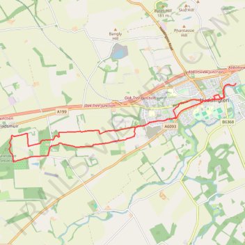
Running near Haddington
- Distance: 9.9 mi
- Elevation gain: 338 ft
- Maximum elevation: 367 ft
- Elevation loss: 335 ft
- Minimum elevation: 144 ft
- Moving time: 1 h 42 m
- Moving speed: 5.8 mph
- Maximum speed: 8.2 mph
- Total time: 1 h 42 m
- Global speed: 5.8 mph
Interactive trail map
Thank you for supporting this site ❤️
Make a donation
Make a donation
Gear up for your next adventure:
As an Amazon Associate, this site earns from qualifying purchases at no extra cost to you.
Trail profile
- Distance: 9.9 mi
- Elevation gain: 338 ft
- Maximum elevation: 367 ft
- Elevation loss: 335 ft
- Minimum elevation: 144 ft
- Moving time: 1 h 42 m
- Moving speed: 5.8 mph
- Maximum speed: 8.2 mph
- Total time: 1 h 42 m
- Global speed: 5.8 mph
Thank you for supporting this site ❤️
Make a donation
Make a donation
Gear up for your next adventure:
As an Amazon Associate, this site earns from qualifying purchases at no extra cost to you.
About this trail
Name: Running near Haddington trail, distance, elevation, map, profile, GPS track
Coordinates: 55.94066 -2.86759 55.95964 -2.77008
Thank you for supporting this site ❤️
Make a donation
Make a donation
Gear up for your next adventure:
As an Amazon Associate, this site earns from qualifying purchases at no extra cost to you.
Other hiking, mountain biking, running and outdoor activity trails
Click on a trail to view its statistics, map and profile.
Fa'side Castle loop from Wallyford
United Kingdom > Scotland > East Lothian > Musselburgh
Distance: 21.3 mi • Elevation gain: 1,165 ft • Maximum elevation: 446 ft