Raccoon Loop Trail in Golden Gate Canyon State Park
Embarking on the Raccoon Loop Trail in Golden Gate Canyon State Park, hikers are treated to a diverse journey through dense coniferous forests and open meadows adorned with seasonal wildflowers. The trail offers panoramic vistas of the snowcapped Continental Divide, Indian Peaks and prominent formations like Tremont Mountain, Thorodin Mountain and Starr Peak. Along the way, the soothing sounds of trickling brooks and sightings of historic cabins enrich the hiking experience. #Hiking #Mountain #Forest #Nature #Loop
- Distance: 2.7 mi
- Elevation gain: 554 ft
- Maximum elevation: 9,291 ft
- Elevation loss: 554 ft
- Minimum elevation: 8,858 ft
- Moving time: 1 h 54 m
- Moving speed: 1.4 mph
- Maximum speed: 2.9 mph
- Total time: 2 h 27 m
- Global speed: 1.1 mph
Interactive trail map
Trail profile
- Distance: 2.7 mi
- Elevation gain: 554 ft
- Maximum elevation: 9,291 ft
- Elevation loss: 554 ft
- Minimum elevation: 8,858 ft
- Moving time: 1 h 54 m
- Moving speed: 1.4 mph
- Maximum speed: 2.9 mph
- Total time: 2 h 27 m
- Global speed: 1.1 mph
About this trail
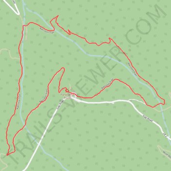
Name: Raccoon Loop Trail in Golden Gate Canyon State Park trail, distance, elevation, map, profile, GPS track
Start: Gap Road, Meadowlake Mountain Acres, Gilpin County, Colorado, United States (39.87582 -105.44041)
End: Raccoon Trail, Gilpin County, Colorado, United States (39.87582 -105.44042)
Coordinates: 39.87215 -105.44585 39.88059 -105.43341
Topography: Gilpin County topographic map, elevation, terrain
Other hiking, mountain biking, running and outdoor activity trails
Click on a trail to view its statistics, map and profile.