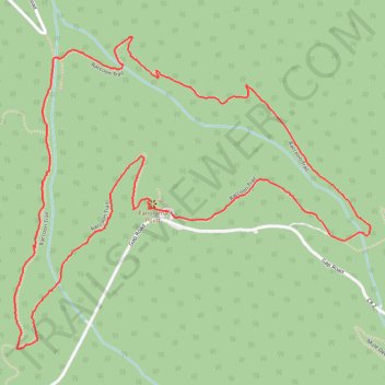
Raccoon Trail
Loop hike on Raccoon Trail in Golden Gate Canyon State Park #Hiking #Mountain #Forest #Loop
- Distance: 2.7 mi
- Elevation gain: 541 ft
- Maximum elevation: 9,291 ft
- Elevation loss: 541 ft
- Minimum elevation: 8,855 ft
- Moving time: 1 h 55 m
- Moving speed: 1.4 mph
- Maximum speed: 2.8 mph
- Total time: 2 h 26 m
- Global speed: 1.1 mph
Interactive trail map
Trail profile
- Distance: 2.7 mi
- Elevation gain: 541 ft
- Maximum elevation: 9,291 ft
- Elevation loss: 541 ft
- Minimum elevation: 8,855 ft
- Moving time: 1 h 55 m
- Moving speed: 1.4 mph
- Maximum speed: 2.8 mph
- Total time: 2 h 26 m
- Global speed: 1.1 mph
About this trail
Name: Raccoon Trail trail, distance, elevation, map, profile, GPS track
Start: Raccoon Trail, Gilpin County, Colorado, United States (39.87583 -105.44043)
End: Raccoon Trail, Gilpin County, Colorado, United States (39.87585 -105.44049)
Coordinates: 39.87215 -105.44592 39.88060 -105.43340
Topography: Gilpin County topographic map, elevation, terrain
Other hiking, mountain biking, running and outdoor activity trails
Click on a trail to view its statistics, map and profile.
Raccoon Loop Trail in Golden Gate Canyon State Park
United States > Colorado > Gilpin County
Embarking on the Raccoon Loop Trail in Golden Gate Canyon State Park, hikers are treated to a diverse journey through dense coniferous forests and open meadows adorned with seasonal wildflowers. The trail offers panoramic vistas of the snowcapped Continental Divide, Indian Peaks and prominent formations like…
Distance: 2.7 mi • Elevation gain: 554 ft • Maximum elevation: 9,291 ft