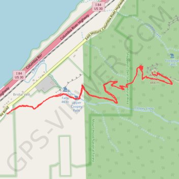
Angel's Rest Trail in Columbia River Gorge National Scenic Area
The Angel’s Rest Trail offers a rewarding hike with sweeping views of the Columbia River, surrounding mountains, and lush forests. As you ascend, the trail passes through forested sections with occasional stream crossings before opening up to vistas, especially after the landscape thinned from past wildfires. At the summit, hikers are treated to breathtaking panoramic views of the Gorge, including Portland and even Washington’s Mt. Adams on clear days, though the final scramble over boulders adds a bit of challenge. #Hiking #Gorge #Forest #River #Nature
- Distance: 4.4 mi
- Elevation gain: 1,598 ft
- Maximum elevation: 1,565 ft
- Elevation loss: 1,578 ft
- Minimum elevation: 177 ft
- Moving time: 1 h 43 m
- Moving speed: 2.5 mph
- Maximum speed: 5.4 mph
- Total time: 2 h 46 m
- Global speed: 1.6 mph
Interactive trail map
Trail profile
- Distance: 4.4 mi
- Elevation gain: 1,598 ft
- Maximum elevation: 1,565 ft
- Elevation loss: 1,578 ft
- Minimum elevation: 177 ft
- Moving time: 1 h 43 m
- Moving speed: 2.5 mph
- Maximum speed: 5.4 mph
- Total time: 2 h 46 m
- Global speed: 1.6 mph
About this trail
Name: Angel's Rest Trail in Columbia River Gorge National Scenic Area trail, distance, elevation, map, profile, GPS track
Coordinates: 45.56018 -122.17258 45.56467 -122.15062
Topography: Multnomah County topographic map, elevation, terrain
Other hiking, mountain biking, running and outdoor activity trails
Click on a trail to view its statistics, map and profile.
Angel's Rest Trail in Mount Hood National Forest
United States > Oregon > Multnomah County > Corbett > Bridal Veil
The Angel's Rest Trail offers a beautiful hike with breathtaking views of the Columbia River Gorge. Starting through a lush forest, hikers will cross small streams and pass scenic waterfalls, including a view of Coopey Falls. As the trail ascends, the forest gives way to more open terrain, where you'll enjoy…
Distance: 4.6 mi • Elevation gain: 1,709 ft • Maximum elevation: 1,562 ft
Expedition to Sedum Ridge
United States > Oregon > Multnomah County > Portland
Distance: 133.4 mi • Elevation gain: 16,709 ft • Maximum elevation: 3,835 ft