Thank you for supporting this site ❤️
Make a donation
Make a donation
Gear up for your next adventure:
As an Amazon Associate, this site earns from qualifying purchases at no extra cost to you.
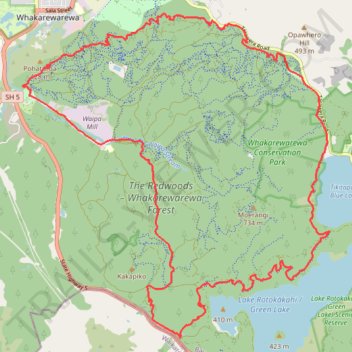
The Redwoods - Whakarewarewa Forest Mountain Biking - Forest Loop
- Distance: 21.8 mi
- Elevation gain: 3,507 ft
- Maximum elevation: 1,696 ft
- Elevation loss: 3,507 ft
- Minimum elevation: 1,053 ft
- Moving time: 2 h 40 m
- Moving speed: 8.2 mph
- Maximum speed: 30.2 mph
- Total time: 3 h 2 m
- Global speed: 7.2 mph
Interactive trail map
Thank you for supporting this site ❤️
Make a donation
Make a donation
Gear up for your next adventure:
As an Amazon Associate, this site earns from qualifying purchases at no extra cost to you.
Trail profile
- Distance: 21.8 mi
- Elevation gain: 3,507 ft
- Maximum elevation: 1,696 ft
- Elevation loss: 3,507 ft
- Minimum elevation: 1,053 ft
- Moving time: 2 h 40 m
- Moving speed: 8.2 mph
- Maximum speed: 30.2 mph
- Total time: 3 h 2 m
- Global speed: 7.2 mph
Thank you for supporting this site ❤️
Make a donation
Make a donation
Gear up for your next adventure:
As an Amazon Associate, this site earns from qualifying purchases at no extra cost to you.
About this trail
Name: The Redwoods - Whakarewarewa Forest Mountain Biking - Forest Loop trail, distance, elevation, map, profile, GPS track
Coordinates: -38.22440 176.25032 -38.15943 176.32841
Thank you for supporting this site ❤️
Make a donation
Make a donation
Gear up for your next adventure:
As an Amazon Associate, this site earns from qualifying purchases at no extra cost to you.
Other hiking, mountain biking, running and outdoor activity trails
Click on a trail to view its statistics, map and profile.
The Redwoods - Whakarewarewa Forest Loop Mountain Biking
New Zealand > Bay of Plenty > Rotorua Lakes District > Rotorua
Distance: 25.1 mi • Elevation gain: 3,760 ft • Maximum elevation: 1,693 ft