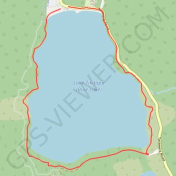
Lake Tikitapu (Blue Lake)
Interactive trail map
Trail profile
- Distance: 3.4 mi
- Elevation gain: 554 ft
- Maximum elevation: 1,601 ft
- Elevation loss: 548 ft
- Minimum elevation: 1,368 ft
About this trail
Name: Lake Tikitapu (Blue Lake) trail, distance, elevation, map, profile, GPS track
Coordinates: -38.20275 176.32409 -38.18731 176.33973
Other hiking, mountain biking, running and outdoor activity trails
Click on a trail to view its statistics, map and profile.
The Redwoods - Whakarewarewa Forest Mountain Biking - Forest Loop
New Zealand > Bay of Plenty > Rotorua Lakes District > Rotorua
Distance: 21.8 mi • Elevation gain: 3,507 ft • Maximum elevation: 1,696 ft
The Redwoods - Whakarewarewa Forest Loop Mountain Biking
New Zealand > Bay of Plenty > Rotorua Lakes District > Rotorua
Distance: 25.1 mi • Elevation gain: 3,760 ft • Maximum elevation: 1,693 ft