Banbury ➡️ Mollington ➡️ Cropredy ➡️ Banbury
- Distance: 13.6 mi
- Elevation gain: 702 ft
- Maximum elevation: 538 ft
- Elevation loss: 705 ft
- Minimum elevation: 308 ft
- Moving time: 2 h 18 m
- Moving speed: 5.9 mph
- Maximum speed: 11.3 mph
- Total time: 2 h 18 m
- Global speed: 5.9 mph
Interactive trail map
Trail profile
- Distance: 13.6 mi
- Elevation gain: 702 ft
- Maximum elevation: 538 ft
- Elevation loss: 705 ft
- Minimum elevation: 308 ft
- Moving time: 2 h 18 m
- Moving speed: 5.9 mph
- Maximum speed: 11.3 mph
- Total time: 2 h 18 m
- Global speed: 5.9 mph
About this trail
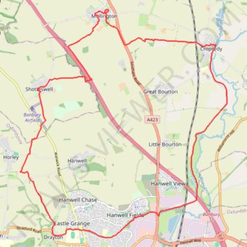
Name: Banbury ➡️ Mollington ➡️ Cropredy ➡️ Banbury trail, distance, elevation, map, profile, GPS track
Coordinates: 52.07254 -1.38753 52.12465 -1.31083
Other hiking, mountain biking, running and outdoor activity trails
Click on a trail to view its statistics, map and profile.
The Jo Cox Way 2022 Day 3 Market Bosworth to Milton Keynes
United Kingdom > England > Leicestershire > Hinckley and Bosworth > Market Bosworth
Distance: 76.4 mi • Elevation gain: 3,127 ft • Maximum elevation: 640 ft
Radway 🔁 Mollington
United Kingdom > England > Warwickshire > Stratford-on-Avon > Radway
Distance: 14.5 mi • Elevation gain: 1,411 ft • Maximum elevation: 715 ft