MTB Tathra
- Distance: 15.4 mi
- Elevation gain: 1,460 ft
- Maximum elevation: 384 ft
- Elevation loss: 1,457 ft
- Minimum elevation: 10 ft
- Moving time: 2 h 3 m
- Moving speed: 7.5 mph
- Maximum speed: 20.9 mph
- Total time: 2 h 4 m
- Global speed: 7.4 mph
Interactive trail map
Trail profile
- Distance: 15.4 mi
- Elevation gain: 1,460 ft
- Maximum elevation: 384 ft
- Elevation loss: 1,457 ft
- Minimum elevation: 10 ft
- Moving time: 2 h 3 m
- Moving speed: 7.5 mph
- Maximum speed: 20.9 mph
- Total time: 2 h 4 m
- Global speed: 7.4 mph
About this trail
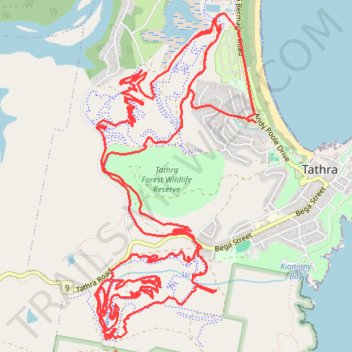
Name: MTB Tathra trail, distance, elevation, map, profile, GPS track
Coordinates: -36.74285 149.96122 -36.71519 149.97829
Other hiking, mountain biking, running and outdoor activity trails
Click on a trail to view its statistics, map and profile.
Tura Beach - Bournda National Park - Mimosa Rocks National Park - Dalmeny
Australia > New South Wales > Tura Beach
Distance: 71.6 mi • Elevation gain: 6,624 ft • Maximum elevation: 492 ft