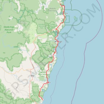
Tura Beach - Bournda National Park - Mimosa Rocks National Park - Dalmeny
- Distance: 71.6 mi
- Elevation gain: 6,624 ft
- Maximum elevation: 492 ft
- Elevation loss: 6,611 ft
- Minimum elevation: -3 ft
Interactive trail map
Trail profile
- Distance: 71.6 mi
- Elevation gain: 6,624 ft
- Maximum elevation: 492 ft
- Elevation loss: 6,611 ft
- Minimum elevation: -3 ft
About this trail
Name: Tura Beach - Bournda National Park - Mimosa Rocks National Park - Dalmeny trail, distance, elevation, map, profile, GPS track
Coordinates: -36.85816 149.89895 -36.15067 150.13837
Other hiking, mountain biking, running and outdoor activity trails
Click on a trail to view its statistics, map and profile.
Dalmeny - Murramarang National Park - Meroo National Park - Dolphin Point (Ulladulla)
Australia > New South Wales > Bodalla
#Bike #Murramarang #Meroo
Distance: 80.2 mi • Elevation gain: 6,339 ft • Maximum elevation: 397 ft
Mallacoota - Tura Beach
Australia > Victoria > Mallacoota
#Bike
Distance: 75.6 mi • Elevation gain: 6,768 ft • Maximum elevation: 535 ft
MTB Tathra
Australia > New South Wales > Tathra
Distance: 15.4 mi • Elevation gain: 1,460 ft • Maximum elevation: 384 ft