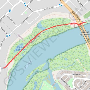
Baigup Wetlands Trail along Swan River
Walk
- Distance: 1.3 mi
- Elevation gain: 43 ft
- Maximum elevation: 43 ft
- Elevation loss: 46 ft
- Minimum elevation: 7 ft
- Moving time: 29 m 47 s
- Moving speed: 2.6 mph
- Maximum speed: 5.1 mph
- Total time: 31 m 17 s
- Global speed: 2.5 mph
Interactive trail map
Trail profile
- Distance: 1.3 mi
- Elevation gain: 43 ft
- Maximum elevation: 43 ft
- Elevation loss: 46 ft
- Minimum elevation: 7 ft
- Moving time: 29 m 47 s
- Moving speed: 2.6 mph
- Maximum speed: 5.1 mph
- Total time: 31 m 17 s
- Global speed: 2.5 mph
About this trail
Name: Baigup Wetlands Trail along Swan River trail, distance, elevation, map, profile, GPS track
Coordinates: -31.93556 115.90742 -31.93125 115.91659
Other hiking, mountain biking, running and outdoor activity trails
Click on a trail to view its statistics, map and profile.
2021 Toodyay return via Kep
Distance: 142.9 mi • Elevation gain: 6,099 ft • Maximum elevation: 1,171 ft