Leederville - Swan Valley
Interactive trail map
Trail profile
- Distance: 32.3 mi
- Elevation gain: 860 ft
- Maximum elevation: 98 ft
- Elevation loss: 856 ft
- Minimum elevation: 3 ft
About this trail
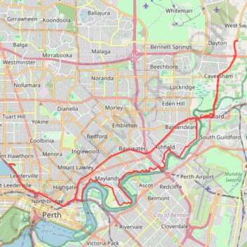
Name: Leederville - Swan Valley trail, distance, elevation, map, profile, GPS track
Coordinates: -31.95115 115.83151 -31.85455 115.98810
Other hiking, mountain biking, running and outdoor activity trails
Click on a trail to view its statistics, map and profile.
Baigup Wetlands Trail along Swan River
Walk
Distance: 1.3 mi • Elevation gain: 43 ft • Maximum elevation: 43 ft
2021 Toodyay return via Kep
Distance: 142.9 mi • Elevation gain: 6,099 ft • Maximum elevation: 1,171 ft
Eric Singleton Bird Sanctuary
Australia > Western Australia > Perth
Distance: 1.1 mi • Elevation gain: 33 ft • Maximum elevation: 30 ft