Make a donation
Gear up for your next adventure:
As an Amazon Associate, this site earns from qualifying purchases at no extra cost to you.
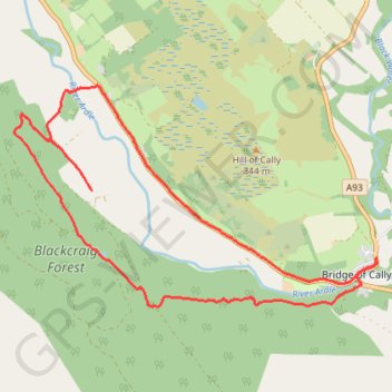
Around Bridge of Cally
- Distance: 8.3 mi
- Elevation gain: 925 ft
- Maximum elevation: 961 ft
- Elevation loss: 925 ft
- Minimum elevation: 515 ft
- Moving time: 59 m 19 s
- Moving speed: 8.4 mph
- Maximum speed: 20.0 mph
- Total time: 1 h 30 m
- Global speed: 5.5 mph
Interactive trail map
Make a donation
Gear up for your next adventure:
As an Amazon Associate, this site earns from qualifying purchases at no extra cost to you.
Trail profile
- Distance: 8.3 mi
- Elevation gain: 925 ft
- Maximum elevation: 961 ft
- Elevation loss: 925 ft
- Minimum elevation: 515 ft
- Moving time: 59 m 19 s
- Moving speed: 8.4 mph
- Maximum speed: 20.0 mph
- Total time: 1 h 30 m
- Global speed: 5.5 mph
Make a donation
Gear up for your next adventure:
As an Amazon Associate, this site earns from qualifying purchases at no extra cost to you.
About this trail
Name: Around Bridge of Cally trail, distance, elevation, map, profile, GPS track
Coordinates: 56.64380 -3.46759 56.66628 -3.40078
Make a donation
Gear up for your next adventure:
As an Amazon Associate, this site earns from qualifying purchases at no extra cost to you.
Other hiking, mountain biking, running and outdoor activity trails
Click on a trail to view its statistics, map and profile.
Alyth to Spittal of Glenshee - Cateran Trail (some of)
United Kingdom > Scotland > Perth and Kinross > Alyth
Distance: 27.4 mi • Elevation gain: 3,720 ft • Maximum elevation: 2,133 ft
Spittal of Glenshee to Alyth - Some of the Cateran Trail
United Kingdom > Scotland > Perth and Kinross > Spittal of Glenshee
Distance: 23.8 mi • Elevation gain: 1,841 ft • Maximum elevation: 1,506 ft