Make a donation
Gear up for your next adventure:
As an Amazon Associate, this site earns from qualifying purchases at no extra cost to you.
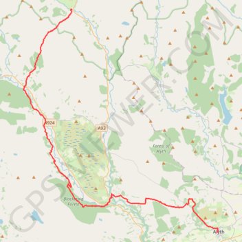
Alyth to Spittal of Glenshee - Cateran Trail (some of)
- Distance: 27.4 mi
- Elevation gain: 3,720 ft
- Maximum elevation: 2,133 ft
- Elevation loss: 2,949 ft
- Minimum elevation: 325 ft
- Moving time: 4 h 3 m
- Moving speed: 6.8 mph
- Maximum speed: 26.9 mph
- Total time: 4 h 41 m
- Global speed: 5.9 mph
Interactive trail map
Make a donation
Gear up for your next adventure:
As an Amazon Associate, this site earns from qualifying purchases at no extra cost to you.
Trail profile
- Distance: 27.4 mi
- Elevation gain: 3,720 ft
- Maximum elevation: 2,133 ft
- Elevation loss: 2,949 ft
- Minimum elevation: 325 ft
- Moving time: 4 h 3 m
- Moving speed: 6.8 mph
- Maximum speed: 26.9 mph
- Total time: 4 h 41 m
- Global speed: 5.9 mph
Make a donation
Gear up for your next adventure:
As an Amazon Associate, this site earns from qualifying purchases at no extra cost to you.
About this trail
Name: Alyth to Spittal of Glenshee - Cateran Trail (some of) trail, distance, elevation, map, profile, GPS track
Start: Alexandra Street, Alyth, Perth and Kinross, Scotland, PH11 8AU, United Kingdom (56.62128 -3.23327)
End: Spittal of Glenshee, Perth and Kinross, Scotland, PH10 7QE, United Kingdom (56.81373 -3.46002)
Coordinates: 56.62128 -3.53599 56.81403 -3.23014
Make a donation
Gear up for your next adventure:
As an Amazon Associate, this site earns from qualifying purchases at no extra cost to you.
Other hiking, mountain biking, running and outdoor activity trails
Click on a trail to view its statistics, map and profile.
Around Kirton of Glenisla, Angus, UK
United Kingdom > Scotland > Angus > Kirkton of Glenisla
Planned eMTB Gravel: Kirkton of Glenisla - 3-hills Loop UK, Angus, Kirkton of Glenisla
Distance: 13.2 mi • Elevation gain: 1,591 ft • Maximum elevation: 1,417 ft
Loop Gravel Ride around Blairgowrie and Rattray between Loch of Clunie and Alyth
United Kingdom > Scotland > Perth and Kinross > Newlands
Distance: 24.7 mi • Elevation gain: 1,736 ft • Maximum elevation: 922 ft
Spittal of Glenshee to Alyth - Some of the Cateran Trail
United Kingdom > Scotland > Perth and Kinross > Spittal of Glenshee
Distance: 23.8 mi • Elevation gain: 1,841 ft • Maximum elevation: 1,506 ft
EMTB Gravel: Auchintaple Loch Loop
United Kingdom > Scotland > Angus > Folda > Little Forter
Around Auchintaple Loch, nr Folda, Angus
Distance: 9.7 mi • Elevation gain: 1,293 ft • Maximum elevation: 1,499 ft
Make a donation
Gear up for your next adventure:
As an Amazon Associate, this site earns from qualifying purchases at no extra cost to you.
Cycle to Loch à Chait, Craigsheal and Buckinhill
United Kingdom > Scotland > Perth and Kinross > Butterstone
Distance: 8.0 mi • Elevation gain: 1,010 ft • Maximum elevation: 1,411 ft
Around Kirkmichael, Perthshire
United Kingdom > Scotland > Perth and Kinross > Kirkmichael
Distance: 4.8 mi • Elevation gain: 289 ft • Maximum elevation: 899 ft
Enochdhu to Upper Lunch Hut Loop
United Kingdom > Scotland > Perth and Kinross > Enochdhu
Mountain Bike Ride
Distance: 6.7 mi • Elevation gain: 863 ft • Maximum elevation: 1,575 ft
Around Loch Ordie
United Kingdom > Scotland > Perth and Kinross
Mountain Bike Ride, UK, Perthshire, Dunkeld
Distance: 22.3 mi • Elevation gain: 1,900 ft • Maximum elevation: 984 ft
Make a donation
Gear up for your next adventure:
As an Amazon Associate, this site earns from qualifying purchases at no extra cost to you.
Around Bridge of Cally
United Kingdom > Scotland > Perth and Kinross > Bridge of Cally > Netherton
Distance: 8.3 mi • Elevation gain: 925 ft • Maximum elevation: 961 ft