Thank you for supporting this site ❤️
Make a donation
Make a donation
Gear up for your next adventure:
As an Amazon Associate, this site earns from qualifying purchases at no extra cost to you.
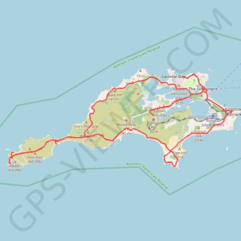
Rottnest Island Mountain Biking Loop
- Distance: 24.2 mi
- Elevation gain: 1,165 ft
- Maximum elevation: 89 ft
- Elevation loss: 1,152 ft
- Minimum elevation: -3 ft
- Moving time: 3 h 5 m
- Moving speed: 7.9 mph
- Maximum speed: 26.1 mph
- Total time: 4 h 11 m
- Global speed: 5.8 mph
Interactive trail map
Thank you for supporting this site ❤️
Make a donation
Make a donation
Gear up for your next adventure:
As an Amazon Associate, this site earns from qualifying purchases at no extra cost to you.
Trail profile
- Distance: 24.2 mi
- Elevation gain: 1,165 ft
- Maximum elevation: 89 ft
- Elevation loss: 1,152 ft
- Minimum elevation: -3 ft
- Moving time: 3 h 5 m
- Moving speed: 7.9 mph
- Maximum speed: 26.1 mph
- Total time: 4 h 11 m
- Global speed: 5.8 mph
Thank you for supporting this site ❤️
Make a donation
Make a donation
Gear up for your next adventure:
As an Amazon Associate, this site earns from qualifying purchases at no extra cost to you.
About this trail
Name: Rottnest Island Mountain Biking Loop trail, distance, elevation, map, profile, GPS track
Coordinates: -32.02586 115.45024 -31.98973 115.55333
Thank you for supporting this site ❤️
Make a donation
Make a donation
Gear up for your next adventure:
As an Amazon Associate, this site earns from qualifying purchases at no extra cost to you.
Other hiking, mountain biking, running and outdoor activity trails
Click on a trail to view its statistics, map and profile.