Thank you for supporting this site ❤️
Make a donation
Make a donation
Gear up for your next adventure:
As an Amazon Associate, this site earns from qualifying purchases at no extra cost to you.
Rottnest Island - City of York Circuit
Interactive trail map
Thank you for supporting this site ❤️
Make a donation
Make a donation
Gear up for your next adventure:
As an Amazon Associate, this site earns from qualifying purchases at no extra cost to you.
Trail profile
- Distance: 5.1 mi
- Elevation gain: 348 ft
- Maximum elevation: 102 ft
- Elevation loss: 348 ft
- Minimum elevation: 0 ft
Thank you for supporting this site ❤️
Make a donation
Make a donation
Gear up for your next adventure:
As an Amazon Associate, this site earns from qualifying purchases at no extra cost to you.
About this trail
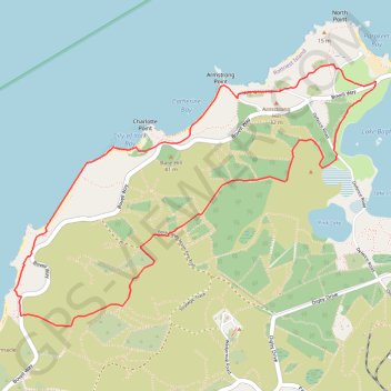
Name: Rottnest Island - City of York Circuit trail, distance, elevation, map, profile, GPS track
Coordinates: -32.00721 115.48715 -31.99011 115.51497
Thank you for supporting this site ❤️
Make a donation
Make a donation
Gear up for your next adventure:
As an Amazon Associate, this site earns from qualifying purchases at no extra cost to you.
Other hiking, mountain biking, running and outdoor activity trails
Click on a trail to view its statistics, map and profile.
Rottnest Island Mountain Biking Loop
Australia > Western Australia > The Settlement
Distance: 24.2 mi • Elevation gain: 1,165 ft • Maximum elevation: 89 ft