Mount Liberty and Mount Flume
Hike to Mount Liberty and Mount Flume via Franconia Notch Bike Path, Liberty Spring Trail and Franconia Ridge Trail in the Franconia Notch State Park and the White Mountain National Forest. #Hiking #Mountain #Nature #Forest #Park
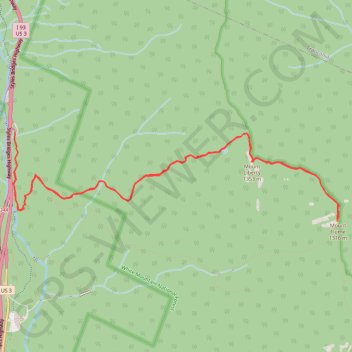
- Distance: 8.9 mi
- Elevation gain: 3,875 ft
- Maximum elevation: 4,360 ft
- Elevation loss: 3,812 ft
- Minimum elevation: 1,447 ft
- Moving time: 4 h 17 m
- Moving speed: 2.1 mph
- Maximum speed: 4.1 mph
- Total time: 5 h 13 m
- Global speed: 1.7 mph
Interactive trail map
Trail profile
- Distance: 8.9 mi
- Elevation gain: 3,875 ft
- Maximum elevation: 4,360 ft
- Elevation loss: 3,812 ft
- Minimum elevation: 1,447 ft
- Moving time: 4 h 17 m
- Moving speed: 2.1 mph
- Maximum speed: 4.1 mph
- Total time: 5 h 13 m
- Global speed: 1.7 mph
About this trail
Name: Mount Liberty and Mount Flume trail, distance, elevation, map, profile, GPS track
Coordinates: 44.10879 -71.68158 44.11921 -71.62790
Topography: Grafton County topographic map, elevation, terrain
Other hiking, mountain biking, running and outdoor activity trails
Click on a trail to view its statistics, map and profile.