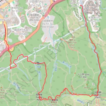
隔田坑左源
Hike
- Distance: 4.6 mi
- Elevation gain: 1,657 ft
- Maximum elevation: 1,339 ft
- Elevation loss: 1,542 ft
- Minimum elevation: 39 ft
- Moving time: 2 h 7 m
- Moving speed: 2.2 mph
- Maximum speed: 10.0 mph
- Total time: 4 h 41 s
- Global speed: 1.2 mph
Interactive trail map
Trail profile
- Distance: 4.6 mi
- Elevation gain: 1,657 ft
- Maximum elevation: 1,339 ft
- Elevation loss: 1,542 ft
- Minimum elevation: 39 ft
- Moving time: 2 h 7 m
- Moving speed: 2.2 mph
- Maximum speed: 10.0 mph
- Total time: 4 h 41 s
- Global speed: 1.2 mph
About this trail
Name: 隔田坑左源 trail, distance, elevation, map, profile, GPS track
Coordinates: 22.35452 114.18035 22.37246 114.20029
Other hiking, mountain biking, running and outdoor activity trails
Click on a trail to view its statistics, map and profile.
長繩脊
China > Hong Kong > Sha Tin District > Chap Wai Kon Village
Distance: 6.6 mi • Elevation gain: 2,605 ft • Maximum elevation: 1,788 ft
Golden Hill Path
China > Hong Kong > Kwai Tsing District > Kwai Chung > Shek Lei Hill Village
Distance: 6.6 mi • Elevation gain: 2,093 ft • Maximum elevation: 997 ft
城門~北潭坳
China > Hong Kong > Tsuen Wan District > Kwai Chung > Lower Shing Mun Village
ShingMunReservoir~PakTamAu
Distance: 23.3 mi • Elevation gain: 7,156 ft • Maximum elevation: 1,808 ft
Dome hill
China > Hong Kong > Sha Tin District > Chap Wai Kon Village > Ngau Pei Sha New Village
Hong Kong Trail Run
Distance: 4.7 mi • Elevation gain: 1,526 ft • Maximum elevation: 1,385 ft
Lion Rock Country Park
China > Hong Kong > Sha Tin District > Tai Wai Village
Distance: 4.7 mi • Elevation gain: 1,243 ft • Maximum elevation: 538 ft
Wilson Trail Full Route
China > Hong Kong > Hong Kong Island
Distance: 50.5 mi • Elevation gain: 14,534 ft • Maximum elevation: 2,011 ft
石籬邨~火炭站
China > Hong Kong > Kwai Tsing District > Kwai Chung > Shek Lei Hang Village
Distance: 7.3 mi • Elevation gain: 2,405 ft • Maximum elevation: 1,572 ft
芒輋瀝 長坑嶺
China > Hong Kong > Sha Tin District > Ha Keng Hau
Outdoor hiking
Distance: 2.6 mi • Elevation gain: 1,063 ft • Maximum elevation: 1,079 ft
長情左坑 彎曲北坑 獅尾坑
China > Hong Kong > Tai Po District > Sai Keng Village > Kei Ling Ha Lo Wai
Hong Kong Hike
Distance: 11.1 mi • Elevation gain: 3,642 ft • Maximum elevation: 1,860 ft
Lion Rock Country Park
Distance: 4.3 mi • Elevation gain: 1,703 ft • Maximum elevation: 1,089 ft
麦理浩径
China > Hong Kong > Sai Kung District > Tsak Yue Wu
北潭涌至屯门
Distance: 61.3 mi • Elevation gain: 16,886 ft • Maximum elevation: 3,031 ft