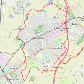
Letchworth Greenway
Route created on plotaroute.com
- Distance: 12.8 mi
- Elevation gain: 528 ft
- Maximum elevation: 354 ft
- Elevation loss: 528 ft
- Minimum elevation: 187 ft
- Moving time: 4 h 6 m
- Moving speed: 3.1 mph
- Maximum speed: 3.4 mph
- Total time: 4 h 6 m
- Global speed: 3.1 mph
Interactive trail map
Trail profile
- Distance: 12.8 mi
- Elevation gain: 528 ft
- Maximum elevation: 354 ft
- Elevation loss: 528 ft
- Minimum elevation: 187 ft
- Moving time: 4 h 6 m
- Moving speed: 3.1 mph
- Maximum speed: 3.4 mph
- Total time: 4 h 6 m
- Global speed: 3.1 mph
About this trail
Name: Letchworth Greenway trail, distance, elevation, map, profile, GPS track
End: Willian, North Hertfordshire, Hertfordshire, England, SG6 2AH, United Kingdom (51.95679 -0.21939)
Coordinates: 51.95063 -0.25246 52.00295 -0.19646
Other hiking, mountain biking, running and outdoor activity trails
Click on a trail to view its statistics, map and profile.
Hitchin Outer Orbital Path (HOOP)
United Kingdom > England > Hertfordshire > North Hertfordshire > Hitchin
Distance: 11.9 mi • Elevation gain: 577 ft • Maximum elevation: 328 ft
Deacon Hill
United Kingdom > England > Hertfordshire > North Hertfordshire
Letchworth, Ickleford, Pirton, Deacon Hill and return
Distance: 16.4 mi • Elevation gain: 961 ft • Maximum elevation: 597 ft
From Royston to Letchworth
United Kingdom > England > Hertfordshire > North Hertfordshire > Royston
Distance: 14.7 mi • Elevation gain: 853 ft • Maximum elevation: 551 ft