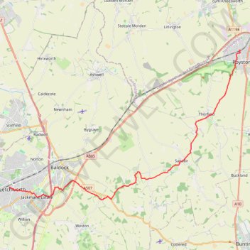
From Royston to Letchworth
- Distance: 14.7 mi
- Elevation gain: 853 ft
- Maximum elevation: 551 ft
- Elevation loss: 768 ft
- Minimum elevation: 190 ft
- Moving time: 5 h 34 m
- Moving speed: 2.6 mph
- Maximum speed: 3.7 mph
- Total time: 6 h 20 m
- Global speed: 2.3 mph
Interactive trail map
Trail profile
- Distance: 14.7 mi
- Elevation gain: 853 ft
- Maximum elevation: 551 ft
- Elevation loss: 768 ft
- Minimum elevation: 190 ft
- Moving time: 5 h 34 m
- Moving speed: 2.6 mph
- Maximum speed: 3.7 mph
- Total time: 6 h 20 m
- Global speed: 2.3 mph
About this trail
Name: From Royston to Letchworth trail, distance, elevation, map, profile, GPS track
Coordinates: 51.97090 -0.23335 52.05355 -0.02562
Other hiking, mountain biking, running and outdoor activity trails
Click on a trail to view its statistics, map and profile.
Deacon Hill
United Kingdom > England > Hertfordshire > North Hertfordshire
Letchworth, Ickleford, Pirton, Deacon Hill and return
Distance: 16.4 mi • Elevation gain: 961 ft • Maximum elevation: 597 ft
Letchworth Greenway
United Kingdom > England > Hertfordshire > North Hertfordshire > Willian
Route created on plotaroute.com
Distance: 12.8 mi • Elevation gain: 528 ft • Maximum elevation: 354 ft
Circuit from Baldock
United Kingdom > England > Hertfordshire > North Hertfordshire > Baldock
Distance: 12.6 mi • Elevation gain: 663 ft • Maximum elevation: 489 ft