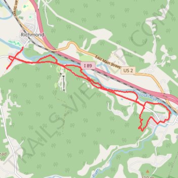
Trails in Richmond along Winooski River
- Distance: 9.3 mi
- Elevation gain: 666 ft
- Maximum elevation: 581 ft
- Elevation loss: 663 ft
- Minimum elevation: 299 ft
- Moving time: 1 h 21 m
- Moving speed: 6.8 mph
- Maximum speed: 11.3 mph
- Total time: 1 h 21 m
- Global speed: 6.8 mph
Interactive trail map
Trail profile
About this trail
Name: Trails in Richmond along Winooski River trail, distance, elevation, map, profile, GPS track
Start: Esplanade Street, Richmond, Chittenden County, Vermont, 05477, United States (44.40184 -72.99666)
Coordinates: 44.37877 -73.00296 44.40184 -72.93997
Topography: Chittenden County topographic map, elevation, terrain
Other hiking, mountain biking, running and outdoor activity trails
Click on a trail to view its statistics, map and profile.