Mount Timpanogos
Via Timpooneke Trail in Uinta-Wasatch-Cache National Forest #Hiking #Mountain #Forest
- Distance: 14.2 mi
- Elevation gain: 5,095 ft
- Maximum elevation: 11,719 ft
- Elevation loss: 5,098 ft
- Minimum elevation: 7,375 ft
- Moving time: 7 h 36 m
- Moving speed: 1.9 mph
- Maximum speed: 3.8 mph
- Total time: 10 h 18 m
- Global speed: 1.4 mph
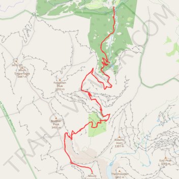
Interactive trail map
Trail profile
- Distance: 14.2 mi
- Elevation gain: 5,095 ft
- Maximum elevation: 11,719 ft
- Elevation loss: 5,098 ft
- Minimum elevation: 7,375 ft
- Moving time: 7 h 36 m
- Moving speed: 1.9 mph
- Maximum speed: 3.8 mph
- Total time: 10 h 18 m
- Global speed: 1.4 mph
About this trail
Name: Mount Timpanogos trail, distance, elevation, map, profile, GPS track
Start: Timpooneke Trail, Utah County, Utah, United States (40.43107 -111.63912)
End: Timpooneke Trail, Utah County, Utah, United States (40.43113 -111.63916)
Coordinates: 40.39097 -111.65490 40.43113 -111.63887
Topography: Utah County topographic map, elevation, terrain
Other hiking, mountain biking, running and outdoor activity trails
Click on a trail to view its statistics, map and profile.
Mount Timpanogos via Timpooneke Trail in Uinta-Wasatch-Cache National Forest
United States > Utah > Utah County
The Timpooneke Trail to Mount Timpanogos offers hikers a stunning journey through the Uinta-Wasatch-Cache National Forest, with sweeping views of alpine meadows, rugged cliffs, and lush forests. Along the way, you’ll be treated to beautiful wildflower-filled valleys, the occasional glimpse of wildlife like…
Distance: 14.4 mi • Elevation gain: 4,984 ft • Maximum elevation: 11,719 ft
Mount Timpanogos Summit via Timpooneke Trail
United States > Utah > Utah County
The Timpooneke Trail to the summit of Mount Timpanogos offers an awe-inspiring hike through diverse landscapes, starting in lush forests and gradually transitioning into alpine meadows and rocky terrain. Along the route, hikers can enjoy expansive views of the Wasatch Mountains, the distant valley below, and…
Distance: 7.1 mi • Elevation gain: 4,823 ft • Maximum elevation: 11,677 ft