Mount Timpanogos Summit via Timpooneke Trail
The Timpooneke Trail to the summit of Mount Timpanogos offers an awe-inspiring hike through diverse landscapes, starting in lush forests and gradually transitioning into alpine meadows and rocky terrain. Along the route, hikers can enjoy expansive views of the Wasatch Mountains, the distant valley below, and dramatic vistas of the summit as the trail ascends. The upper portions provide sweeping panoramas and the opportunity to spot wildlife, such as mountain goats, and beautiful high-altitude lakes, making it a rewarding journey for those seeking both scenic beauty and a physical challenge. #Hiking #Mountain #Forest #Nature
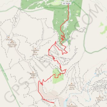
- Distance: 7.1 mi
- Elevation gain: 4,823 ft
- Maximum elevation: 11,677 ft
- Elevation loss: 525 ft
- Minimum elevation: 7,375 ft
Interactive trail map
Trail profile
- Distance: 7.1 mi
- Elevation gain: 4,823 ft
- Maximum elevation: 11,677 ft
- Elevation loss: 525 ft
- Minimum elevation: 7,375 ft
About this trail
Name: Mount Timpanogos Summit via Timpooneke Trail trail, distance, elevation, map, profile, GPS track
Start: Timpooneke Trail, Utah County, Utah, United States (40.43113 -111.63915)
End: Timpanogos Summit Trail, Utah County, Utah, United States (40.39190 -111.64652)
Coordinates: 40.39183 -111.65480 40.43113 -111.63890
Topography: Utah County topographic map, elevation, terrain
Other hiking, mountain biking, running and outdoor activity trails
Click on a trail to view its statistics, map and profile.
Mount Timpanogos via Timpooneke Trail in Uinta-Wasatch-Cache National Forest
United States > Utah > Utah County
The Timpooneke Trail to Mount Timpanogos offers hikers a stunning journey through the Uinta-Wasatch-Cache National Forest, with sweeping views of alpine meadows, rugged cliffs, and lush forests. Along the way, you’ll be treated to beautiful wildflower-filled valleys, the occasional glimpse of wildlife like…
Distance: 14.4 mi • Elevation gain: 4,984 ft • Maximum elevation: 11,719 ft