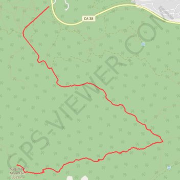
Sugarloaf Mountain
Interactive trail map
Trail profile
- Distance: 6.0 mi
- Elevation gain: 3,074 ft
- Maximum elevation: 9,944 ft
- Elevation loss: 180 ft
- Minimum elevation: 7,051 ft
About this trail
Name: Sugarloaf Mountain trail, distance, elevation, map, profile, GPS track
Start: Wildhorse Meadow Road, San Bernardino County, California, United States (34.23129 -116.80674)
End: Sugarlump Trail, San Bernardino County, California, 92386, United States (34.19899 -116.81452)
Coordinates: 34.19725 -116.81452 34.23129 -116.77856
Topography: San Bernardino County topographic map, elevation, terrain
Other hiking, mountain biking, running and outdoor activity trails
Click on a trail to view its statistics, map and profile.
Sugarloaf Mountain Hiking Route
United States > California > San Bernardino County
Distance: 5.9 mi • Elevation gain: 1,549 ft • Maximum elevation: 9,948 ft