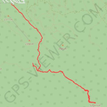
Sugarloaf Mountain Hiking Route
- Distance: 5.9 mi
- Elevation gain: 1,549 ft
- Maximum elevation: 9,948 ft
- Elevation loss: 2,753 ft
- Minimum elevation: 7,303 ft
- Moving time: 3 h 23 m
- Moving speed: 1.7 mph
- Maximum speed: 4.6 mph
- Total time: 5 h 59 m
- Global speed: 1.0 mph
Interactive trail map
Trail profile
- Distance: 5.9 mi
- Elevation gain: 1,549 ft
- Maximum elevation: 9,948 ft
- Elevation loss: 2,753 ft
- Minimum elevation: 7,303 ft
- Moving time: 3 h 23 m
- Moving speed: 1.7 mph
- Maximum speed: 4.6 mph
- Total time: 5 h 59 m
- Global speed: 1.0 mph
About this trail
Name: Sugarloaf Mountain Hiking Route trail, distance, elevation, map, profile, GPS track
Start: Sugarlump Trail, San Bernardino County, California, 92386, United States (34.21077 -116.83709)
Coordinates: 34.19890 -116.84486 34.22855 -116.81426
Topography: San Bernardino County topographic map, elevation, terrain
Other hiking, mountain biking, running and outdoor activity trails
Click on a trail to view its statistics, map and profile.