Parramatta Valley Cycleway and Parramatta Park Loop Ride
The Parramatta Valley Cycleway and Parramatta Park Loop Ride offer a delightful escape into nature, winding alongside the picturesque Parramatta River. You'll encounter stunning views of the river, charming heritage sites like Old Government House, and the lush greenery of Parramatta Park, making it a perfect ride for both history buffs and nature lovers. With its well-maintained paths and easy accessibility, this route is ideal for cyclists of all levels, providing a refreshing blend of outdoor adventure and cultural exploration. #Bike #Park #River #City #Nature
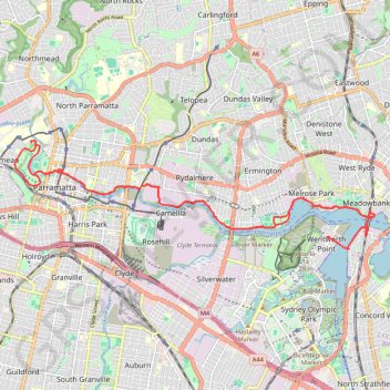
- Distance: 19.8 mi
- Elevation gain: 896 ft
- Maximum elevation: 105 ft
- Elevation loss: 896 ft
- Minimum elevation: -3 ft
- Moving time: 1 h 21 m
- Moving speed: 14.5 mph
- Maximum speed: 25.5 mph
- Total time: 1 h 33 m
- Global speed: 12.6 mph
Interactive trail map
Trail profile
- Distance: 19.8 mi
- Elevation gain: 896 ft
- Maximum elevation: 105 ft
- Elevation loss: 896 ft
- Minimum elevation: -3 ft
- Moving time: 1 h 21 m
- Moving speed: 14.5 mph
- Maximum speed: 25.5 mph
- Total time: 1 h 33 m
- Global speed: 12.6 mph
About this trail
Name: Parramatta Valley Cycleway and Parramatta Park Loop Ride trail, distance, elevation, map, profile, GPS track
Coordinates: -33.82812 150.99175 -33.80333 151.09100
Other hiking, mountain biking, running and outdoor activity trails
Click on a trail to view its statistics, map and profile.
The Ponds Walk: Carlingford - Rydalmere
Australia > New South Wales > Sydney
Distance: 4.9 mi • Elevation gain: 89 ft • Maximum elevation: 417 ft
Sydney Loop Ride via Homebush Bay, Powells Creek, Hudson Park, Cooks River Cycleway, Cooks to Cove Greenway, Hawthorne Canal and Iron Cove
Australia > New South Wales > Sydney
Distance: 33.9 mi • Elevation gain: 1,125 ft • Maximum elevation: 112 ft
Wentworth Point - Parramatta Park
Australia > New South Wales > Sydney
Morning Ride
Distance: 20.4 mi • Elevation gain: 879 ft • Maximum elevation: 105 ft
Ride to George Kindall Riverside Park
Australia > New South Wales > Sydney
Distance: 8.7 mi • Elevation gain: 410 ft • Maximum elevation: 69 ft
Parramatta River Afternoon Ride
Australia > New South Wales > Sydney
Distance: 15.1 mi • Elevation gain: 692 ft • Maximum elevation: 105 ft
Parramatta River Morning Ride
Australia > New South Wales > Sydney
Distance: 14.9 mi • Elevation gain: 676 ft • Maximum elevation: 105 ft
Parramatta River
Australia > New South Wales > Sydney
Morning Ride
Distance: 19.5 mi • Elevation gain: 932 ft • Maximum elevation: 105 ft
Parramatta Ride
Australia > New South Wales > Sydney
Afternoon Ride
Distance: 17.0 mi • Elevation gain: 784 ft • Maximum elevation: 105 ft
Auburn Circle
Australia > New South Wales > Sydney
Distance: 17.3 mi • Elevation gain: 354 ft • Maximum elevation: 121 ft
Lunch Ride
Australia > New South Wales > Sydney
Distance: 17.5 mi • Elevation gain: 758 ft • Maximum elevation: 105 ft