Thank you for supporting this site ❤️
Make a donation
Make a donation
Gear up for your next adventure:
As an Amazon Associate, this site earns from qualifying purchases at no extra cost to you.
Warragul Park
Interactive trail map
Thank you for supporting this site ❤️
Make a donation
Make a donation
Gear up for your next adventure:
As an Amazon Associate, this site earns from qualifying purchases at no extra cost to you.
Trail profile
- Distance: 0.4 mi
- Elevation gain: 46 ft
- Maximum elevation: 427 ft
- Elevation loss: 46 ft
- Minimum elevation: 377 ft
- Moving time: 6 m 33 s
- Moving speed: 3.7 mph
- Maximum speed: 4.8 mph
- Total time: 6 m 33 s
- Global speed: 3.7 mph
Thank you for supporting this site ❤️
Make a donation
Make a donation
Gear up for your next adventure:
As an Amazon Associate, this site earns from qualifying purchases at no extra cost to you.
About this trail
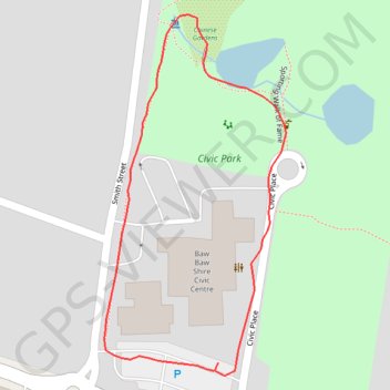
Name: Warragul Park trail, distance, elevation, map, profile, GPS track
Start: 1, Civic Place, Warragul, Shire of Baw Baw, Victoria, 3820, Australia (-38.15937 145.93377)
End: Albert Street, Warragul, Shire of Baw Baw, Victoria, 3820, Australia (-38.15942 145.93373)
Coordinates: -38.15945 145.93286 -38.15719 145.93431
Thank you for supporting this site ❤️
Make a donation
Make a donation
Gear up for your next adventure:
As an Amazon Associate, this site earns from qualifying purchases at no extra cost to you.