Mount Jefferson
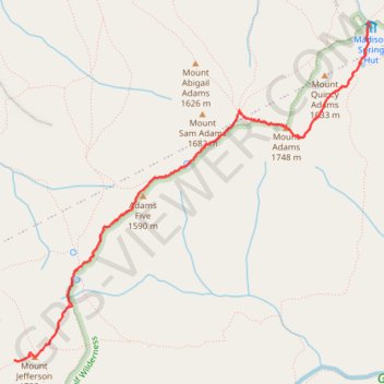
Hike from Madison Spring Hut to Mount Jefferson via Star Lake, Mount Adams, Israel Ridge, Gulfside Trail and Mount Jefferson Trail in the Great Gulf Wilderness and the White Mountain National Forest. #Hiking #Mountain #Nature #Forest #Wilderness
- Distance: 3.1 mi
- Elevation gain: 1,713 ft
- Maximum elevation: 5,755 ft
- Elevation loss: 958 ft
- Minimum elevation: 4,790 ft
- Moving time: 2 h 1 m
- Moving speed: 1.5 mph
- Maximum speed: 13.0 mph
- Total time: 2 h 58 m
- Global speed: 1.0 mph
Interactive trail map
Trail profile
- Distance: 3.1 mi
- Elevation gain: 1,713 ft
- Maximum elevation: 5,755 ft
- Elevation loss: 958 ft
- Minimum elevation: 4,790 ft
- Moving time: 2 h 1 m
- Moving speed: 1.5 mph
- Maximum speed: 13.0 mph
- Total time: 2 h 58 m
- Global speed: 1.0 mph
About this trail
Name: Mount Jefferson trail, distance, elevation, map, profile, GPS track
Coordinates: 44.30385 -71.31873 44.32806 -71.28336
Topography: Coos County topographic map, elevation, terrain
Other hiking, mountain biking, running and outdoor activity trails
Click on a trail to view its statistics, map and profile.
Presidential Range Traverse
United States > New Hampshire > Coos County > Bowman
Starting near the northern gateway of the Presidential Range, this traverse climbs from the forests of the White Mountain National Forest to the exposed ridgeline of Mount Madison, then continues over the rugged summits of Mount Adams and Mount Jefferson, with wide views across the Great Gulf and the…
Distance: 20.1 mi • Elevation gain: 8,350 ft • Maximum elevation: 6,270 ft
Mount Adams and Mount Madison Loop
United States > New Hampshire > Coos County > Randolph
Loop hike from Appalachia Trailhead to Mount Adams and Mount Madison via Airline Trail, Gulfside Trail, Madison Spring Hut, Osgood Trail, Watson Path and Valley Way in the Whites Mountains National Forest. #Hiking #Loop #Mountain #Nature #Forest
Distance: 8.5 mi • Elevation gain: 4,957 ft • Maximum elevation: 5,755 ft