Ben Howard (24622956)
Ben Howard (24622956)
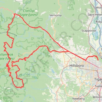
- Distance: 225.8 mi
- Elevation gain: 38,881 ft
- Maximum elevation: 3,304 ft
- Elevation loss: 38,885 ft
- Minimum elevation: 171 ft
Interactive trail map
Trail profile
- Distance: 225.8 mi
- Elevation gain: 38,881 ft
- Maximum elevation: 3,304 ft
- Elevation loss: 38,885 ft
- Minimum elevation: 171 ft
About this trail
Name: Ben Howard (24622956) trail, distance, elevation, map, profile, GPS track
Coordinates: 45.36873 -123.68807 45.86737 -122.78409
Topography: Portland topographic map, elevation, terrain
Other hiking, mountain biking, running and outdoor activity trails
Click on a trail to view its statistics, map and profile.
Crown Zellerbach Rail Trail
United States > Oregon > Columbia County
Distance: 5.0 mi • Elevation gain: 768 ft • Maximum elevation: 1,257 ft
Northwest Firelane 15 Road
United States > Oregon > Multnomah County > Portland
Distance: 4.0 mi • Elevation gain: 758 ft • Maximum elevation: 1,033 ft
Saint Helens Waterfront Park
United States > Oregon > Columbia County > Saint Helens
Distance: 1.0 mi • Elevation gain: 62 ft • Maximum elevation: 46 ft