Make a donation
Gear up for your next adventure:
As an Amazon Associate, this site earns from qualifying purchases at no extra cost to you.
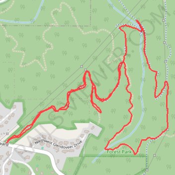
Northwest Firelane 15 Road
- Distance: 4.0 mi
- Elevation gain: 758 ft
- Maximum elevation: 1,033 ft
- Elevation loss: 758 ft
- Minimum elevation: 669 ft
- Moving time: 1 h 50 m
- Moving speed: 2.2 mph
- Maximum speed: 7.0 mph
- Total time: 2 h 34 m
- Global speed: 1.6 mph
Interactive trail map
Make a donation
Gear up for your next adventure:
As an Amazon Associate, this site earns from qualifying purchases at no extra cost to you.
Trail profile
- Distance: 4.0 mi
- Elevation gain: 758 ft
- Maximum elevation: 1,033 ft
- Elevation loss: 758 ft
- Minimum elevation: 669 ft
- Moving time: 1 h 50 m
- Moving speed: 2.2 mph
- Maximum speed: 7.0 mph
- Total time: 2 h 34 m
- Global speed: 1.6 mph
Make a donation
Gear up for your next adventure:
As an Amazon Associate, this site earns from qualifying purchases at no extra cost to you.
About this trail
Name: Northwest Firelane 15 Road trail, distance, elevation, map, profile, GPS track
Coordinates: 45.59555 -122.82368 45.60412 -122.80892
Topography: Portland topographic map, elevation, terrain
Make a donation
Gear up for your next adventure:
As an Amazon Associate, this site earns from qualifying purchases at no extra cost to you.
Other hiking, mountain biking, running and outdoor activity trails
Click on a trail to view its statistics, map and profile.
Ben Howard (24622956)
United States > Oregon > Multnomah County > Portland
Ben Howard (24622956)
Distance: 225.8 mi • Elevation gain: 38,881 ft • Maximum elevation: 3,304 ft