Thank you for supporting this site ❤️
Make a donation
Make a donation
Gear up for your next adventure:
As an Amazon Associate, this site earns from qualifying purchases at no extra cost to you.
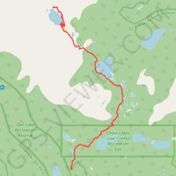
Fowl Lakes trail
- Distance: 6.7 mi
- Elevation gain: 2,169 ft
- Maximum elevation: 5,810 ft
- Elevation loss: 433 ft
- Minimum elevation: 3,996 ft
- Moving time: 3 h 1 m
- Moving speed: 2.2 mph
- Maximum speed: 22.0 mph
- Total time: 3 h 24 m
- Global speed: 2.0 mph
Interactive trail map
Thank you for supporting this site ❤️
Make a donation
Make a donation
Gear up for your next adventure:
As an Amazon Associate, this site earns from qualifying purchases at no extra cost to you.
Trail profile
- Distance: 6.7 mi
- Elevation gain: 2,169 ft
- Maximum elevation: 5,810 ft
- Elevation loss: 433 ft
- Minimum elevation: 3,996 ft
- Moving time: 3 h 1 m
- Moving speed: 2.2 mph
- Maximum speed: 22.0 mph
- Total time: 3 h 24 m
- Global speed: 2.0 mph
Thank you for supporting this site ❤️
Make a donation
Make a donation
Gear up for your next adventure:
As an Amazon Associate, this site earns from qualifying purchases at no extra cost to you.
About this trail
Name: Fowl Lakes trail trail, distance, elevation, map, profile, GPS track
Coordinates: 50.40402 -122.80440 50.45127 -122.77209
Thank you for supporting this site ❤️
Make a donation
Make a donation
Gear up for your next adventure:
As an Amazon Associate, this site earns from qualifying purchases at no extra cost to you.
Other hiking, mountain biking, running and outdoor activity trails
Click on a trail to view its statistics, map and profile.