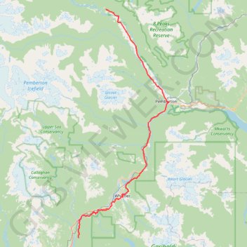
Cheakamus River and Lillooet River
Bikepack from Daisy Lake along Cheakamus River and Lillooet River via Alta Lake, Whistler, Green Lake, Shadow Lake, Nairn Falls, One Mile Lake and Pemberton. #Bike #Nature #River #Lake #Mountain #Forest
- Distance: 52.6 mi
- Elevation gain: 4,045 ft
- Maximum elevation: 2,474 ft
- Elevation loss: 4,810 ft
- Minimum elevation: 682 ft
- Moving time: 5 h 19 m
- Moving speed: 9.9 mph
- Maximum speed: 45.4 mph
- Total time: 8 h 49 m
- Global speed: 6.0 mph
Interactive trail map
Trail profile
- Distance: 52.6 mi
- Elevation gain: 4,045 ft
- Maximum elevation: 2,474 ft
- Elevation loss: 4,810 ft
- Minimum elevation: 682 ft
- Moving time: 5 h 19 m
- Moving speed: 9.9 mph
- Maximum speed: 45.4 mph
- Total time: 8 h 49 m
- Global speed: 6.0 mph
About this trail
Name: Cheakamus River and Lillooet River trail, distance, elevation, map, profile, GPS track
Coordinates: 50.02664 -123.10282 50.51727 -122.79832
Other hiking, mountain biking, running and outdoor activity trails
Click on a trail to view its statistics, map and profile.
Wedgemount Lake - Wedgemount Glacier
Canada > British Columbia > Squamish-Lillooet Regional District > Area C (Pemberton Valley/Mount Currie/D'Arcy)
Garibaldi Provincial Park. #Hiking #Wedgemount #Garibaldi
Distance: 9.3 mi • Elevation gain: 4,557 ft • Maximum elevation: 6,394 ft
Rethel Mountain via Wedgemount Lake Trail
Canada > British Columbia > Squamish-Lillooet Regional District > Area C (Pemberton Valley/Mount Currie/D'Arcy)
Distance: 9.0 mi • Elevation gain: 5,860 ft • Maximum elevation: 7,867 ft
Owl-Tenquille traverse south of Ogre Lake
Canada > British Columbia > Squamish-Lillooet Regional District > Area C (Pemberton Valley/Mount Currie/D'Arcy)
Distance: 2.3 mi • Elevation gain: 384 ft • Maximum elevation: 5,965 ft
Whistler - Rainbow Lake
Canada > British Columbia > Squamish-Lillooet Regional District > Whistler
Distance: 5.2 mi • Elevation gain: 2,726 ft • Maximum elevation: 4,787 ft
Fowl Lakes trail
Canada > British Columbia > Squamish-Lillooet Regional District > Area C (Pemberton Valley/Mount Currie/D'Arcy)
Distance: 6.7 mi • Elevation gain: 2,169 ft • Maximum elevation: 5,810 ft
Path Segment 1
Canada > British Columbia > Squamish-Lillooet Regional District > Area C (Pemberton Valley/Mount Currie/D'Arcy)
Distance: 2.2 mi • Elevation gain: 3,228 ft • Maximum elevation: 5,774 ft