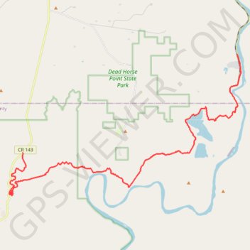
Import a GPX file

Shafer Trail

Moab, UT - Shafer Trail

  • Distance: 20.4 mi
  • Elevation gain: 4,852 ft
  • Maximum elevation: 5,919 ft
  • Elevation loss: 2,894 ft
  • Minimum elevation: 3,950 ft

Interactive trail map

Trail profile

  • Distance: 20.4 mi
  • Elevation gain: 4,852 ft
  • Maximum elevation: 5,919 ft
  • Elevation loss: 2,894 ft
  • Minimum elevation: 3,950 ft

About this trail

Name: Shafer Trail trail, distance, elevation, map, profile, GPS track

Start: Potash Road, Grand County, Utah, United States (38.52776 -109.65556)

End: Shafer Trail, San Juan County, Utah, United States (38.47146 -109.81149)

Coordinates: 38.44718 -109.82115 38.52776 -109.65308

Topography: Grand County topographic map, elevation, terrain

Other hiking, mountain biking, running and outdoor activity trails

Click on a trail to view its statistics, map and profile.

Dead Horse Point and Shafer Canyon Overlook Loop

United States > Utah > San Juan County

Loop hike to Dead Horse Point via East Rim Trail and West Rim Trail in the Dead Horse Point State Park. #Hiking #Loop #Canyon #Mountain #Nature #Park

Distance: 5.7 mi • Elevation gain: 2,415 ft • Maximum elevation: 6,027 ft

Gear up for your next adventure:

🔋Solar Power Banks - Keep your GPS and phone charged in remote wilderness areas
🧤Tactile Hiking Gloves - Keep hands warm while operating GPS and smartphone screens
👟Trail Running Shoes - Lightweight shoes for trail runners
🍳Camping Cook Set - Complete cookware for outdoor meals
🚗GPS Dash Cams - Record your scenic drives through mountain passes and canyons

As an Amazon Associate, this site earns from qualifying purchases at no extra cost to you.