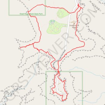
Dead Horse Point and Shafer Canyon Overlook Loop
Loop hike to Dead Horse Point via East Rim Trail and West Rim Trail in the Dead Horse Point State Park. #Hiking #Loop #Canyon #Mountain #Nature #Park
- Distance: 5.7 mi
- Elevation gain: 2,415 ft
- Maximum elevation: 6,027 ft
- Elevation loss: 2,418 ft
- Minimum elevation: 5,561 ft
- Moving time: 4 h 23 m
- Moving speed: 1.3 mph
- Maximum speed: 3.4 mph
- Total time: 5 h 32 m
- Global speed: 1.0 mph
Interactive trail map
Trail profile
- Distance: 5.7 mi
- Elevation gain: 2,415 ft
- Maximum elevation: 6,027 ft
- Elevation loss: 2,418 ft
- Minimum elevation: 5,561 ft
- Moving time: 4 h 23 m
- Moving speed: 1.3 mph
- Maximum speed: 3.4 mph
- Total time: 5 h 32 m
- Global speed: 1.0 mph
About this trail
Name: Dead Horse Point and Shafer Canyon Overlook Loop trail, distance, elevation, map, profile, GPS track
Coordinates: 38.46908 -109.75044 38.48803 -109.73436
Topography: San Juan County topographic map, elevation, terrain
Other hiking, mountain biking, running and outdoor activity trails
Click on a trail to view its statistics, map and profile.
Shafer Trail
United States > Utah > Grand County
Moab, UT - Shafer Trail
Distance: 20.4 mi • Elevation gain: 4,852 ft • Maximum elevation: 5,919 ft