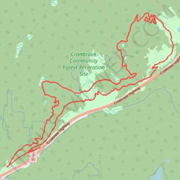
Bike trail in Cranbrook Community Forest BC
- Distance: 7.8 mi
- Elevation gain: 886 ft
- Maximum elevation: 3,219 ft
- Elevation loss: 886 ft
- Minimum elevation: 2,940 ft
- Moving time: 1 h 20 m
- Moving speed: 5.8 mph
- Maximum speed: 15.3 mph
- Total time: 1 h 49 m
- Global speed: 4.3 mph
Interactive trail map
Trail profile
- Distance: 7.8 mi
- Elevation gain: 886 ft
- Maximum elevation: 3,219 ft
- Elevation loss: 886 ft
- Minimum elevation: 2,940 ft
- Moving time: 1 h 20 m
- Moving speed: 5.8 mph
- Maximum speed: 15.3 mph
- Total time: 1 h 49 m
- Global speed: 4.3 mph
About this trail
Name: Bike trail in Cranbrook Community Forest BC trail, distance, elevation, map, profile, GPS track
Coordinates: 49.55003 -115.72867 49.57336 -115.68979
Other hiking, mountain biking, running and outdoor activity trails
Click on a trail to view its statistics, map and profile.